


North Col – North East Ridge Route

First Step: 27,890ft — Second Step: 28,140ft — Third Step: 28,510ft
All heights are approx.
Base Camp to Advanced Base Camp (ABC)
Base Camp is situated on a gravel plain just below the Rongbuk Monastery. From here to ABC it is about a 12 mile trek along the Rongbuk Glacier which is mostly made up of small boulders, with some snow and ice, up to the East Rongbuk Glacier. Here you will walk among the ice towers, which can be up to a 100 foot tall, before arriving into ABC.
ABC to Camp 1
ABC is located on rocky and broken ground, and at times can be very windy. From here you follow the fairly easy to moderate route up the East Rongbuk Glacier, and then up the snow slopes to the North Col, which is where you will find Camp 1
Camp 1 to Camp 2
The North Col Camp sits on a saddle between Everest and Changtse. This camp can be at times extremely windy. From the saddle you follow the long moderate snow slope, which eventually changes to a mixture of rock and snow, to the snow ledge where Camp 2 is normally placed.
Camp 2 to Camp 3
Due to a lack of good camping spots at Camp 2, most tents will end up being pitched uncomfortably on down facing rock ledges. The route between Camp 2 and Camp 3 is traditionally very windy. The terrain is made up of rock and shingle steps, which is all fairly easy, but a slip here could mean certain death. There are fixed ropes in place to offer some security.
Camp 3 to Camp 4
Camp 3 is a deafening place to be because of the roar of the wind. From Camp 3 some climbers will start to use oxygen support. The route is a mixture of rock steps and medium snow slopes. There is the help of the fixed rope, but this is mainly used to stop you from taking the wrong direction rather than secure you to the mountain.
Camp 4 to Summit
Camp 4 is small and uncomfortable, but your aim is to spend as little time here as possible. All climbers are on oxygen support now, except the very brave. Leaving Camp 4 in the dark you ascend into the Yellow Band, which in places is steep, up onto the North East Ridge. Along this ridge you will come across your first obstacle, the First Step. The First Step is a short rock buttress about 100 feet in height. This Step is quite straightforward but can be challenging at this altitude. Some steep and exposed climbing will then lead you onto the Second Step. The Second Step is the hardest of all three Steps. It is in two sections, the lower part consists of large boulders, and then a steep snow gully that leads you onto the fixed ladder. Overall it is about a 130feet in height. After another short climb you come up against the Third Step. This Step is said to be the easiest off all three. It is a 80 foot high lump of rock, that you can either climb, or go around it on the steep snowslopes. Once this last Step is dealt with you will then find yourself on the Summit Pyramid. This is a steep snowfield that ends about 60 foot below the summit. Then all that is between you and the summit is the medium snow slope, which will lead you to the top of the world.
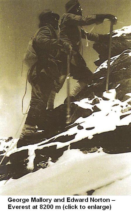
There is one of most famous photo in the world.
George Mallory and Edward Norton – Everest at 8200 m. They ascended without use of oxygen.
British expedition – 1922 r.
take a look at my photo gallery which pictures the story of the discovery and climbing the Mt. Everest :
- discovery and climbing Everest.
- oryginal post by :
http://himalman.wordpress.com/
* Previous story :- Routes to summit Mount Everest.
- Routes of Mt Everest part 1. Drogi na szczyt Mt. Everest cz.1. /Version english and polish/
George Mallory wraz z Edwardem Nortonem sfotografowani na wysokości 8200 m po północnej stronie Everestu , wspinają się bez tlenu mając skromne wyposażenie.
To zdjęcie z wyprawy z 1922r obiegło cały świat , stając się jednym z najsławniejszych zdjęć na świecie.
Więcej ciekawych zdjęć z pierwszych wypraw chcących zdobyć Everest zobaczysz klikając na link : - discovery and climbing Everest.

Drogi na szczyt Everestu.
Mapa powyżej przedstawia drogę na szczyt Everestu od strony Tybetu. Była to droga jaką Brytyjczycy podejmowali próby zdobycia szczytu w latach 1921 d0 1938 r. Były to próby niestety nieudane , pierwszego zdobycia Everestu dokonano bowiem od strony Nepalu. Do dziś droga ta uważana jest za tą trudniejszą.
Na zdjęciu pokazano usytuowanie poszczególnych obozów w drodze na szczyt Everestu, ale należy zwrócić uwagę , że to współczesny plan obozów, nieco inny niż ten z lat dwudziestych i trzydziestych.
Podobna drogą zdobywał szczyt polski himalaista młodego pokolenia Marcin Miotk. Jego wyczyn jest tym cenniejszy , że było to zdobycie szczytu bez tlenu i bez pomocy Sherpów !!!

Droga wejściowa - Everest North 2005 - pierwsze polskie wejście bez użycia tlenu.
Więcej o wyprawach Marcina na stronie www.miotk.pl- oryginal post by : - http://himalman.wordpress.com/
![]()


![]()
** zapraszam na relacje z wypraw polskich himalaistów.


0 Response to "Routes of Mt Everest part 2. Drogi na szczyt Mt. Everest cz.2. /Version english and polish/"