Cerro Aconcagua is the highest mountain in the Americas 6,962 metres (22,841 ft), and the highest mountain outside Asia. It is located in the Andes mountain range, in the Argentine province of Mendoza. The summit is located about 5 kilometres from San Juan Province and 15 kilometres from the international border with Chile. It lies 112 km (70 mi) west by north of the city of Mendoza. Aconcagua is the highest peak in both the Western and Southern Hemispheres. It is one of the Seven Summits.

Aconcagua is bounded by the Valle de las Vacas to the north and east and the Valle de los Horcones Inferior to the West and South. The mountain and its surroundings are part of the Aconcagua Provincial Park. The mountain has a number of glaciers. The most substantial are the north-eastern or Polish Glacier and the eastern or English Glacier.
The mountain was created by the subduction of the Nazca Plate beneath the South American plate during the geologically recent Andean orogeny; however, it is not a volcano.[2] The origin of the name is contested, it is either from the Arauca Aconca-Hue, which refers to the Aconcagua River and means 'comes from the other side' or the Quechua Ackon Cahuak, meaning 'Sentinel of Stone'.

Aconcagua with Patagonicas – Trip Description
ACONCAGUA POLISH GLACIER EXPEDITION
Route Description.
We will continue to approach the Polish Glacier via the Guanacos Valley and traverse the mountain. If you are signing up for the Polish Glacier Route you need to have previous high altitude experience, and be very familiar with the use of ice axe, crampons, and belaying techniques. We are specialized in the Polish Glacier Route, having successfully guided it many times.
Aconcagua Polish Glacier
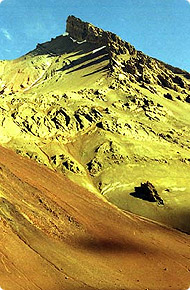
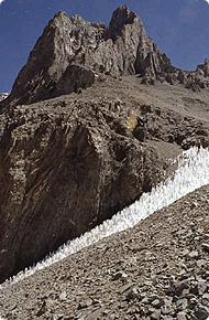
The line we choose will depend on conditions. If a lot of penitentes (snow pinnacles formed by direct sunlight) are encountered in the lower section of the glacier, we will start by climbing through the scree and rock on the right hand side.
Guanacos Valley
The steeper Polish Glacier Direct Route has been the choice route in recent years. Although steeper, it is safer and easier due to fewer icy and exposed traverses than on the old Polish Route. On this spectacular, steep snow and ice climb we will use several running belays.
Moving to High Camp 19,200
In steeper icy sections we will climb pitches instead of using running belays, belaying and regrouping at every anchor. A long day of climbing will take us to the Summit Ridge at 22,000' after the last steep pitch; a 55-60 degree narrow gully with the entire Glacier below at our feet. The final ridge is very long and gentle. After summiting, we descend quickly down the Normal Route to Independencia (20,790') where we descend to our High Camp at 19,200' to rest and spend the night. The next day we descend the Normal Route.
Polish Glacier Route Itinerary.
For a more detailed trip overview and itinerary , click here.
DAY 1: Group meets in Mendoza, Argentina. Equipment check and afternoon briefing at the hotel. For dinner we will have a chance to taste fine Argentinean cuisine and wine.
DAY 2: Drive West from Mendoza to Penitentes ski area at 8,500 . Our drive winds along the Rio Mendoza deep into the heart of the rugged Andes mountains where we begin our acclimatization in Penitentes. An afternoon hike is recommended, though optional.
DAY 3-4-5: Approach to Plaza Guanacos Base Camp. Mules carry our gear. This approximately 35 mile  approach is essential to our acclimatization. Our first two days we follow the same route as Aventuras Patagonicas old Traverse and Polish Glacier Expeditions. The third day begins our new approach. We continue up the Vacas Valleyinstead of ascending the Relinchos Valley. The chances of seeing other expeditions on this new exciting route is remote. The chance of seeing numerous wildlife is much moreprobable. Spectacular glaciers contrasting with a desert backdrop make this approach both surreal and unforgettable. We have an excellent chance of seeing herds of guanacos. When Rodrigo did an exploratory trip to the region he encountered several hundred, counting 80 in one sighting alone! These magnificent mammals are well camouflaged, extremely elusive and a rare sight in the Aconcagua region.
DAY 6: Plaza Guanaco Base Camp at 13,000 . Rest and acclimatization day at Base Camp. We want everyone to have the best possible chance to make the summit. The most effective way to do this is to take the time to acclimatize to the low oxygen environment. We will incorporate rest days into our schedule and climb in traditional expedition style. We will be carrying loads up to the next camp and returning to sleep below at the previous camp. The next day we will move to the higher camp environment.
DAY 7: Carry a load to Camp I at approximately 15,200. The route goes up the narrow valley between the North side of Cerro Ameghino and Cerro San Francisco. Here we will be able to see Nieve Penitentes, unique snow and ice formations created by the direct sun. Return to Base Camp.
DAY 8: Leave Base Camp. Move to Camp I.
DAY 9: Carry a load to Camp II at 16,500 . Fantastic view of the Polish Glacier. We ascend scree slopes to a broad ridge crest where we will establish Camp II.
DAY 10: Move to Camp II.
DAY 11: Carry a load to Camp III, below the Polish Glacier at 17,800 .
DAY 12: Move to Camp III. depending on how group is doing.
DAY 13: Carry a load to High Camp, at 19,200 . We will establish this camp at the base of the Polish Glacier.
DAY 14: Move to High Camp.
DAY 15-17: Summit! Weather permitting. We allow several days for our Summit Day in case of poor weather.
DAY 18: Descend the Normal Route to Plaza de Mulas Base Camp. This will be quite exciting since we will be descending a different side of the mountain.
DAY 19: Hike out the Horcones Valley, with its impressive views of Aconcagua s South Face. Spend the night in Penitentes.
DAY 20: Drive to Mendoza. Enjoy delicious team banquet! Next day fly home or continue traveling in South America.
Note: This itinerary is intended to be a guideline only, weather days and rest days are always a possibility while on a climbing expedition.
For a more detailed : - http://patagonicas.com/index.html
.. more : 1 - http://www.andesmountain.cl/indexaco_ing.htm
2 - http://www.aconcagua-express.com/
3 - http://www.aconcaguaexpeditions.com/
*Previous story : - Seven Summits.
Aconcagua with Patagonia - Agencja górska.
Aconcagua - wyprawa z Ryszardem Pawłowskim.
Ryszard Pawłowski - światowej sławy himalaista, zaprasza na wyprawy by zdobywać wspaniałe szczyty na wszystkich kontynentach.
..jego sylwetka na : - Ryszard Pawłowski the famous Polish climber. /Version english and polish/
W najrozleglejszych górach świata, Andach, położony jest najwyższy szczyt obu Ameryk i zarazem najwyższy szczyt wznoszący się poza Azją - Aconcaqua.
Góra nazwana przez Inków Acconcahuac (co w ich języku oznacza "kamienny straznik") stanowi jeden z filarów "Korony Ziemi" co czyni ją szczególnie atrakcyjną dla wspinaczy.
Aconcaqua leży w argentyńskiej prowincji Mendoza, 15 km od granicy z Chile. Jest masywem pochodzenia wulkanicznego, swoja wysokością znacznie przewyższa sąsiednie wierzchołki, wydając się jeszcze wyższa niż jest w istocie.
Otaczające ja góry pokryte są jałowymi, stromymi zboczami , stanowiącymi pustynny teren z usuwającymi się spod nóg kamieniami. Roślinność jest tu bardzo uboga i praktycznie zanika na wysokości ok. 4000 m co potęguje wrażenie pustki i surowości i sprawia że rejon ten odwiedzany jest niemal wyłącznie przez wojskowych i wspinaczy.
Szczególne wrażenie robi pionowa, południowa ściana widziana z doliny Horcones - ścianą tą, wśród barier seraków i ruchomych skał, prowadzą najtrudniejsze drogi na wierzchołek.
  | Lista sprzętu do zabrania na wyprawę:
|
Pamiętaj, nawet najlepszy sprzęt nie zapewni Ci wejścia na szczyt
bez przygotowania kondycyjnego i nastawienia psychicznego!
1897 - szwajcarski przewodnik M. Zurbriggen, członek brytyjskiej ekspedycji pod kierownictwem E. Fitzgeralda, zdobywa szczyt 14 stycznia wchodząc od strony zachodniej, drogą uznawaną dzisiaj za klasyczną
1934 - czworka polskich wspinaczy: K. Narkiewicz-Jodko, S. Daszyński, W. Ostrowski i S. Osiecki dokonują pierwszego wejscia od strony wschodniej przez lodowiec, zwany odtąd Lodowcem Polaków
1954 - uczestnicy francuskiej wyprawy G.Poulet, R.Paragot, E.Denis, P. Lasueur, L. Bernardini i A.Dagory jako pierwsi pokonują trudny centralny filar na scianie południowej osiagając wierzchołek 28 lutego
1974 - austriacko-włoska wyprawa Reinholda Messnera dokonuje prostowania w górnym odcinku drogi francuskiej z 1954. Siedemnaście lat póżniej, ta samą drogę pokonuje samotnie Austriak T. Bubendorfer
1982 - czterej Słoweńcy Z. Gantar, I. Rejc oraz bracia Pavel i Peter Podgornik po dziewięciodniowej wspinaczce na południowej ścianie osiągają południowy wierzchołek góry. Obecnie droga ta, nazwana "słoweńską", uznawana jest za najtrudniejszą na całej górze.
Krótka informacja o wyprawie:
Celem wyprawy jest wejście na szczyt Aconcaqua - najwyższy szczyt obu Ameryk.
Wybieramy jeden z dwóch klasycznych wariantów osiągnięcia wierzchołka tzn. od północnego wschodu, rozpoczynając z miejscowości Punta del Inca. Po trzech dniach marszu przez doliny Vacas i Relinchos docieramy do bazy Plaza Argentina, ulokowanej na wysokości 4200 m. Do tego miejsca bagaż transportowany jest na grzbietach mułów; powyżej bazy cały niezbędny sprzęt transportują uczestnicy, przy okazji zdobywając aklimatyzację i kondycję.
Przez następne parę dni zakładamy kolejne obozy: obóz I na wysokości ok. 5300 m oraz obóz II na wysokości ok. 5950 m. Przy dobrych warunkach pogodowych wejście na szczyt z obozu II zajmuje ok. 8-10 godzin, czas wejścia uzależniony jest przede wszystkim od (oprócz pogody) samopoczucia uczestników.
Program akcji górskiej jest tak ułożony, aby w razie nieudanego wejścia na szczyt np. ze względu na złą pogodę lub gorsze samopoczucie, możliwe było ponowienie ataku.
Do bazy wracamy tą samą trasą, likwidując po drodze kolejne obozy.
Warunki pogodowe jakie napotkamy podczas wyprawy są ekstremalne i skrajnie różne - od zenitalnego słońca na początku podejścia do ujemnych temperatur, lodu, sniegu i silnych wiatrów w wyższych partiach góry.
Samo wejście na Aconcaque nie stwarza większych trudności technicznych, pamiętać jednak należy, że znaczna wysokość (prawie 7000 m) oraz często występujące trudne warunki pogodowe sprawiają, że wejście na wierzchołek jest zawsze poważnym przedsięwzięciem.
*Previous story : - Seven Summits.
- oryginal post by : - http://himalman.wordpress.com/
** zapraszam na relacje z wypraw polskich himalaistów.










I climbed Aconcagua in February, is experiencie of life time. Nice site!